Severe thunderstorms to usher in fall-like conditions ahead of Labor Day

By AccuWeather senior meteorologist
Mother Nature has given little relief from the summery conditions for those in the Northeast this month. But now, forecasters say that a noticeable change to the weather could be on the way before the final weekend of summer.
From west to east early in the week, temperatures will be on the rise, followed by a surge of humidity. Temperatures in places from Pittsburgh and Detroit to New York City and Boston will top out in the upper 80s Monday. AccuWeather RealFeel® Temperatures are expected to sneak into the upper 90s.

“The unseasonably warm, humid air in place early this week can set the stage for a dramatic clash of air masses,” explained AccuWeather Meteorologist Mary Gilbert.
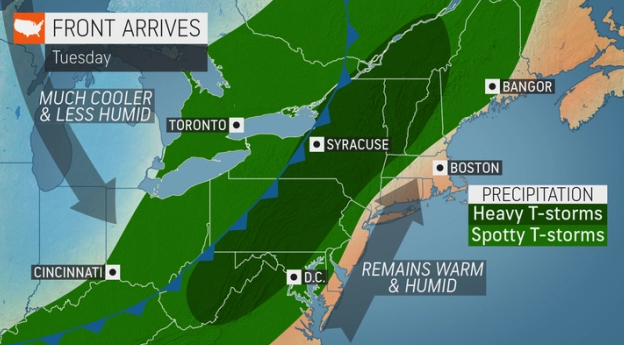
While a warm and sticky situation is building in the Northeast into Monday, a cooler air mass from Canada will be working its way into the United States by way of a cold front. As the front progresses through the northern tier of the country, it will ignite severe thunderstorms from the Plains to the Midwest.
Thunderstorms as early as Monday afternoon could reach the eastern Great Lakes and interior Northeast. Wet weather will encompass more of the region Tuesday.
“This potent cold front is set to swing through the Northeast on Tuesday and bring the opportunity for some potentially powerful storms,” said Gilbert.
Widespread thunderstorms are expected in southern Canada, the interior Northeast, and much of the Appalachians and Mid-Atlantic.

For many across the Northeast, rainfall could be considered welcome.
Despite a few rounds of wet weather targeting the northeastern U.S. over the past week, more than 50% of the area is abnormally dry, according to the U.S. Drought Monitor. In New England, the drought conditions are even worse. 96% of Massachusetts is in severe or extreme drought, while the entirety of Rhode Island is in an extreme drought.
Any stint of wet weather for the region could help to ease the growing drought conditions. Should several rounds of rain hit the same location, it’s possible that it could be enough rain to bust the drought completely in portions of Pennsylvania, New York and New Jersey.

However, with how dry the area has been, the much-needed rainfall comes at the risk of flooding. Should the downpours be too heavy, the rainfall would be less likely to be absorbed by the dry ground and instead just run off.
Heavy downpours will increase the potential for flooding in more urban locations as well. Travelers should be on the lookout for ponding on roadways, especially in low-lying spots.
“This round of thunderstorms can serve as a reminder to residents of the Northeast that summer, and its volatile weather, isn’t over just yet,” Gilbert said.
In addition to the threat of more widespread flooding downpours, Gilbert warned that Tuesday’s thunderstorms could contain damaging wind gusts and maybe even hail.

Not every location at risk for flooding downpours is expected to encounter severe thunderstorms; however, the area from the St. Lawrence Valley of southern Quebec to central Virginia will be most at risk.
Following the thunderstorms, the cool air from Canada will settle into the region. More fall-like conditions will start as early as Tuesday for parts of the Great Lakes and Ohio Valley. By Wednesday, relief will be felt across the Northeast and the central Appalachians. After a high of 95 on Tuesday and dew points around 70, Philadelphia can expect highs back in the middle 80s and dew points plummeting to the upper 50s.
The Eastern Seaboard, from Portland, Maine, to Charleston, South Carolina, will have to wait until Thursday, the first day of September, for the refreshing change to arrive.
Those across the Northeast and mid-Atlantic may especially notice the cooler conditions in the mornings or the late evenings when temperatures could be feeling a little more like fall.

Dry conditions and a lack of humidity are likely to linger through late in the week and during the start of the Labor Day holiday weekend, giving a fall-like preview for the unofficial end to summer.
Earlier this summer, AccuWeather long-range meteorologists released the Fall 2022 forecast. Despite the upcoming reprieve from the mild conditions, forecasters expect a warmer-than-normal start to autumn.